The new long range outlooks from NOAA’s Climate Prediction Center were released this week. There was little new information for much of the Corn Belt except in the shorter term. Let’s review some of the information included.
For January another major pattern shift is expected from late December into at least early January where a period of colder than average conditions is very likely throughout the Northern Plains/Upper Midwest. The 30 day outlook for January reflects that cold area with an increased chance of cold temperatures from the Midwest and central Plains southward. The main issues related to this are on potential winter wheat damage with the cold and to livestock. There are no precipitation indications different from average during January through the region.
For the 90 day outlook (January – March) the outlooks still bank on El Nino having an impact as the outlooks are largely El Nino-looking. Specifically this includes cooler temperatures more likely across the southern part of the Midwest, drier than average more likely over the Great Lakes and Ohio Valley and potential for increased precipitation in the central plains.
The current El Nino status is that Sea Surface temperatures are in El Nino territory, but have not persisted as long as needed for classification as an El Nino. Therefore, El Nino is still pending. Even if El Nino does occur (current probability is 65%) the impacts are likely weaker because this is going to be a weak El Nino. Therefore, whether the CPC outlooks will play out is somewhat in question over the 90 day period.
Looking ahead to the planting season there are no strong indications of issues at this point other than the drier than average area in the outlooks over the Great Lakes/Ohio Valley. Dry soil moisture conditions have impacted much of the corn belt during the fall, which aided harvest. But these soils will need some recharge come spring. The eastern Dakotas and much of Minnesota are reflected as Abnormally Dry (D0) on the US Drought Monitor. At this point most of these issues with dry soils are only potential problems and could actually aid in spring planting allowing soils to warm more quickly and more readily allow field work. Conditions will have to be monitored for changes during the next few months based on the rest of winter precipitation and early spring rainfalls.
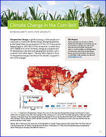 Researchers with the Climate and Corn-based Cropping Systems Coordinated Agricultural Project (commonly known as the Sustainable Corn Project) have documented 130 findings. This new publication of findings explains how climate change is impacting and will continue to impact weather in the Corn Belt. Author Raymond Arritt’s research encompasses mesoscale meteorology, regional climate, and aerobiology in the Departments of Agronomy and Geological and Atmospheric Sciences at Iowa State University, Ames, Iowa. You can download the report HERE.