About Dennis Todey

Dennis Todey is the state climatologist for South Dakota and Associate Professor at South Dakota State University. He is a frequent speaker on current climate conditions and outlooks across the northern plains and Midwest. Crop conditions, drought and yield impacts are also frequent topics for discussion. Formerly from Iowa, he has been at SDSU since 2003.

New Outlooks and Impact on the 2015 Planting Season

As we reach the latter part of April the whole Corn Belt is well into planting season, though corn planting progress is a little slow so far. Several contrasting issues are impacting planting across the Corn Belt and into the Northern and Central Plains.

Planting in much of the eastern Corn Belt has been slowed a little by early season wetness particularly in the southeastern parts (Illinois, Indiana, Missouri and Ohio) where heavier than average precipitation over the last 30-60 days has kept conditions wetter, keeping planters out of the fields. Areas in the Ohio River Valley have seen 150-200% of average precipitation or more in the last 30 days. In contrast much of the plains area (Dakotas to Kansas) has seen much drier conditions leading to increase in coverage on the US Drought Monitor.

The wet conditions have slowed corn planting compared to average across the southern and eastern areas of the Corn Belt. Continue reading

November – December Temperature Swings


The late cold snap in December changed what could have been a rather historic situation, one where average December temperatures were actually warmer than November temperatures.  Data is gradually coming in completing the data for the month of December.  The much colder than average temperatures over the after Christmas have helped to bring down the December averages to close to, but generally slightly cooler than November overall.


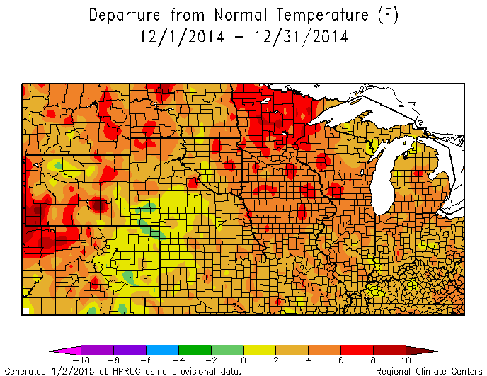
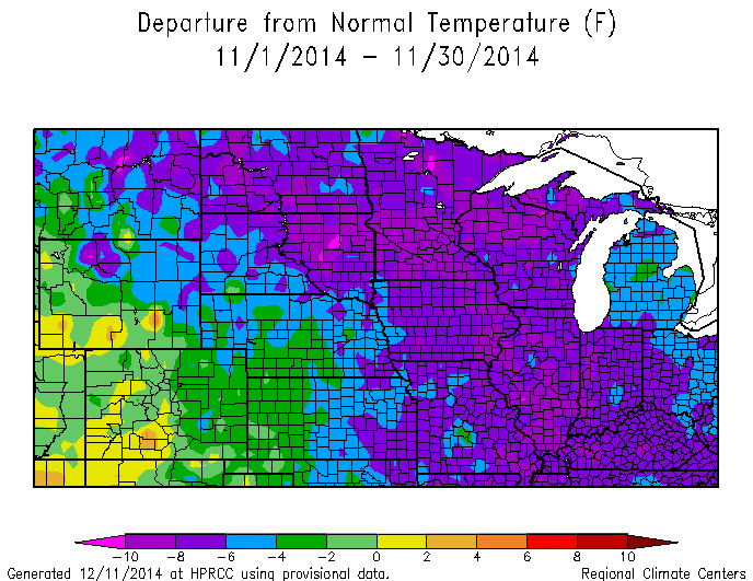
To review what happened over the last two months, November started quite warm, but turned very cold in the middle of the month setting a large number of temperature records as sub-0 F temperatures showed up across parts of the Corn Belt mush earlier than usual.  November ended at 6-10 F below average.  The cold carried on into the first part of December when a sharp change occurred with very warm temperatures across the Corn Belt in December with most of the Upper Midwest 4-8 F above average.    See attached images.

Nov14TDeptNWSCR Dec14TDeptNWSCR

Final data are still being accumulated.  Most of the stations around the Midwest and northern plains were within a couple degrees between the two months.  The large majority of stations ended up slightly colder in December than November.  But a few stations largely in northern areas ended up warmer in December than November.

How odd is this situation?  First we have to look at climatology.  There is a range of results across the Corn Belt comparing averages for the two months.  But generally the average difference between November and December is 10-14 F.  So that they are even close show the oddity of the event with November that cold and December that warm.

Has it ever happened?  In some locations, no.  But we can go back to a couple years and find a number of stations where it has happened, 1896 and 1959.  Many stations have both of these with more showing the situation in 1959.

Enjoy the little bit of climatic history.

New Long Range Outlooks – El Nino

The new long range outlooks from NOAA’s Climate Prediction Center were released this week.  There was little new information for much of the Corn Belt except in the shorter term.  Let’s review some of the information included.

For January another major pattern shift is expected from late December into at least early January where a period of colder than average conditions is very likely throughout the Northern Plains/Upper Midwest.  The 30 day outlook for January reflects that cold area with an increased chance of cold temperatures from the Midwest and central Plains southward.  The main issues related to this are on potential winter wheat damage with the cold and to livestock.  There are no precipitation indications different from average during January through the region.

For the 90 day outlook (January – March) the outlooks still bank on El Nino having an impact as the outlooks are largely El Nino-looking.  Specifically this includes cooler temperatures more likely across the southern part of the Midwest, drier than average more likely over the Great Lakes and Ohio Valley and potential for increased precipitation in the central plains.

The current El Nino status is that Sea Surface temperatures are in El Nino territory, but have not persisted as long as needed for classification as an El Nino.  Therefore, El Nino is still pending.  Even if El Nino does occur (current probability is 65%) the impacts are likely weaker because this is going to be a weak El Nino.  Therefore, whether the CPC outlooks will play out is somewhat in question over the 90 day period.

Looking ahead to the planting season there are no strong indications of issues at this point other than the drier than average area in the outlooks over the Great Lakes/Ohio Valley.  Dry soil moisture conditions have impacted much of the corn belt during the fall, which aided harvest.  But these soils will need some recharge come spring.  The eastern Dakotas and much of Minnesota are reflected as Abnormally Dry (D0) on the US Drought Monitor.  At this point most of these issues with dry soils are only potential problems and could actually aid in spring planting allowing soils to warm more quickly and more readily allow field work.  Conditions will have to be monitored for changes during the next few months based on the rest of winter precipitation and early spring rainfalls.

What’s up with El Nino?

What’s up with El Nino?  Short answer is still not too much.  The monthly El Nino summary has been posted today at the Climate Prediction Center (see link below). The basic message is that reaching El Nino conditions is still likely (now 58%) lower than last month. Conditions in the Pacific are still not coming together well in the coupling between ocean and atmosphere. Sea surface temperatures are relatively warm.

The long range outlooks still are based on El Nino conditions occurring (updates will come out in 2 weeks). But the weak El Nino would allow other variables to impact what happens this winter including changes in the North Pacific, North Atlantic and over the pole.

End result is that some things that look like El Nino are still likely to happen during the winter.  But the confidence of being a very warm winter in the northern US is somewhat less.  The likelihood is lower because of the reduced El Nino chances.  And even if El Nino does occur, weak El Ninos have less overall influence and can more easily be modified by other conditions.

See the full outlook from the Climate Prediction Center:

http://www.cpc.ncep.noaa.gov/products/analysis_monitoring/enso_advisory/

Corn belt heat into early September

The main part of the Corn belt is going to get some help with heat over the next couple weeks while the northern and western corn belt will hold steady or lose ground compared to average on GDD accumulation.

The 8-14 day outlooks have been consistent over the last few days holding in a ridge of the main part of the corn belt.  This situation will allow above average temperatures during this period.  The additional heat will be very beneficial for the development of corn, which has been lagging a little through the season in certain places.  See the 8-14 day outlook:

http://www.cpc.ncep.noaa.gov/

Northern areas of the Corn belt have been running further behind development throughout the year and have acres that are at risk of not reaching maturity or being harvested at very high moisture content based on the freeze date and additional heat through the rest of the season.

If you wish to check where you corn crop sits with current development check out this tool from the USDA – AFRI funded U2U group:

https://mygeohub.org/groups/u2u/decision_resources

This tool allows you to check development based on your location, planting date and variety.  Updated daily it gives you the chance to check conditions anywhere in the corn belt.

The most recent outlook will not help with the slower development across the northwestern corn belt.  This area will need to have a longer period this fall to reach maturity and dry down.


Cool Temperatures and Corn Yield

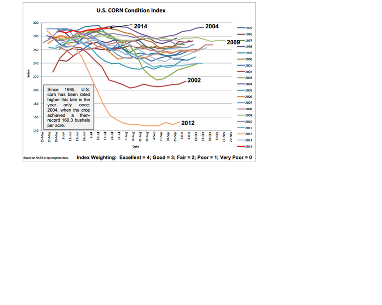
The most recent Weekly Weather and Crop Bulletin on Wednesday 23 July included the following image on corn conditions across the Corn Belt.  Note that since 1995 only one other year has had a higher overall corn condition rating at this point in the growing season – 2004.

corn condition july 2014

Source:  Weekly Weather and Crop Bulletin: http://www.usda.gov/oce/weather/pubs/Weekly/Wwcb/wwcb.pdf

This image clearly shows the impact of the overall cooler temperatures this summer. While the cool weather has been attracting some media attention for the lack of mid-summer heat, for the most part the cool has been very good for crop conditions over the bulk of the Corn Belt.  Where moisture is not limited the crop has been able to grow well.  Where moisture has been limited the reduced atmospheric demands of the cooler temperatures has reduced potential stress and allowed much of the corn crop to pass through tasseling with limited stress.  Note that 2004 – the then-record yield – was also a very cool summer.

Even when conditions have warmed, they have been short-lived and often accompanied by high dew points, additionally reducing the atmospheric demand on crops.

The next question becomes – can we put on enough GDDs to get the crop to reach maturity in time?  The current 6-10 and 8-14 day outlooks stay cool.  The previous blog post by Jim Angel talked about the outlook for the rest of the growing season.

Spring/summer outlook and El Nino

The January long range outlooks were released two weeks ago.  The main themes are continued similar overall pattern is expected into February and possibly into spring.  Colder conditions are more likely in the northern plains with no strong indications on precipitation except for some increased chances in the Ohio Valley.

The more interesting feature in the outlooks is not mentioned in the outlooks directly.  Recent forecasts for El Nino have been showing Continue reading

Fall Crop Harvest Weather, Progress and Impacts

What was possibly going to be a late harvest season with the late planting and cooler mid-summer temperatures has moved ahead quicker than expected.  Late season warmth and dryness pushed crops progress along and also pushed many to premature maturity because of a lack of moisture accompanying the heat in the late summer.  Thus, crops that were expected to stay green well into the fall have not.  A warm and relatively dry September also aided that situation.  Continue reading

Drought issues returning

drmon

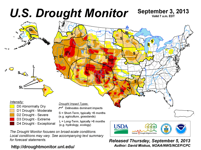
The most recent US Drought Monitor map shows drought returning to larger parts of the Corn Belt in the last few weeks. This has been driven by warm temperatures over the last part of August. Dryness has existed across parts of IA, MN and SD over the middle part of the summer. But cool temperatures during that same period had reduced the stress on crops. With the return of warm temperatures in the latter part of August, the dry areas began showing stress quickly.

Areas of Iowa and Missouri have degraded to D2-Severe Drought with surrounding areas of SD, MN, and IA with D1 – Moderate Drought.

In some ways the heat in the latter part of August was welcomed in pushing crops along to development. But the extended period of heat without moisture is stressing crops, pushing some to early maturity and browning.

Large parts of the central part of the corn belt are watching for freezing conditions because of the late development. We will post more about that as information becomes available.

Crop Progress 7-17

The latest crop progress data for corn and beans. In the main Corn Belt 16% of the crop has tasseled compared to the 5 year average of 35%. Obviously early season cold temperatures and late planting are still affecting overall development. The most glaring data are from Iowa and Minnesota where only 1% of the crop is tasseling where they should be around 29% and 24% respectively. This has affected markets a little. While there is expected to be ample corn available based on USDA planting reports, the late development of the crop always presents a little concern for a couple reasons.

1) Delayed tasseling pushes the critical reproductive period of corn later in the summer when higher average temperatures and lesser chances for precipitation increase the chance for stress. With some corn planted in very wet conditions there is even greater concern this year with limited root growth.

2) Later development pushes chances for an early freeze to damage crops. This is far enough out that we cannot talk about it specifically as to when a freeze might occur. But the delay in development will certainly push maturity closer to the freeze date.

New climate outlooks will be posted later this week looking at the rest of the growing season.