
As we reach the latter part of April the whole Corn Belt is well into planting season, though corn planting progress is a little slow so far. Several contrasting issues are impacting planting across the Corn Belt and into the Northern and Central Plains.
Planting in much of the eastern Corn Belt has been slowed a little by early season wetness particularly in the southeastern parts (Illinois, Indiana, Missouri and Ohio) where heavier than average precipitation over the last 30-60 days has kept conditions wetter, keeping planters out of the fields. Areas in the Ohio River Valley have seen 150-200% of average precipitation or more in the last 30 days. In contrast much of the plains area (Dakotas to Kansas) has seen much drier conditions leading to increase in coverage on the US Drought Monitor.
The wet conditions have slowed corn planting compared to average across the southern and eastern areas of the Corn Belt. Most states were behind the 5 year average and reporting slow progress in any field work due to wet conditions according to the most recent USDA-NASS weekly crop reports. The southern storm track has stayed fairly strong through the latter part of winter and early spring brining repeated storms across the area. Northern areas have had systems come through but with little moisture available to produce precipitation.
The dry conditions across the north and west have been somewhat of a benefit to small grains planting in the across northern and plains areas. In all states small grains planting is reported as ahead of the 5 year average due to overall warm conditions and dry soils. Spring wheat, oats and other small grains planting has been able to proceed well ahead of last year and 5 year averages due to warmer soil temperatures and dry soils.
Winter wheat across the larger winter wheat areas in the plains has experienced a difficult growing season impacted by several issues
• Fall dryness
• Spring dryness
• Delayed planting in some locations
• Early cold in November
• Winterkill
Other winter damage to horticultural crops and alfalfa in Wisconsin and Michigan due to extreme cold, not cold after breaking dormancy. The extent of the damage was still being noted in the various crops.
The current US Drought Monitor map has a large area of D1 and D0 across the western and northern Corn Belt. Moderate Drought (D1) exists over large parts of the Dakotas, Minnesota, Wisconsin, Nebraska and Kansas. Abnormally dry (D0) surrounds most of that area into Iowa, northern Illinois and Michigan.
South Dakota has its driest January to March on record. The whole northern tier of the Corn Belt was in the top 10 driest except for North Dakota.
Outlooks
Part of the outlooks have some large influence of the current (and likely to continue through summer) El Nino event. This will be addressed in a follow-up post in the next couple days along with a review of the Climate Patterns Viewer Tool.
Cool and dry conditions are dominating the eastern Corn Belt as of late April. This situation is not likely to continue into May according to information from NOAA’s Climate Prediction Center (http://www.cpc.ncep.noaa.gov) . Temperatures should rebound in early May allowing for better crop planting and progress. Dryness is only more likely to continue more immediately around the Great Lakes from May into early summer. This signal has shown up in the dynamic computer models.
Most of the rest of the Corn Belt is Equal Chances for below and above average precipitation with western plains areas having a higher likelihood of above average precipitation.
Looking further ahead into the growing season an area of cooler than average conditions appears over the I-states in the latter part of the summer. This is likely from El Nino impacts. The precipitation chances are more likely higher than expected from the plains reaching across Nebraska by the latter part of summer.
The overall assessment would be more likely recovery of precipitation shortfalls in the plains areas, with lesser chances for recovery further north. The wet areas of the east should begin to dry. The delayed planting will have to be watched for GDD accumulation in the season particularly in the areas with more likely cooler conditions later in the summer.
Jan-Mar 2015 precip
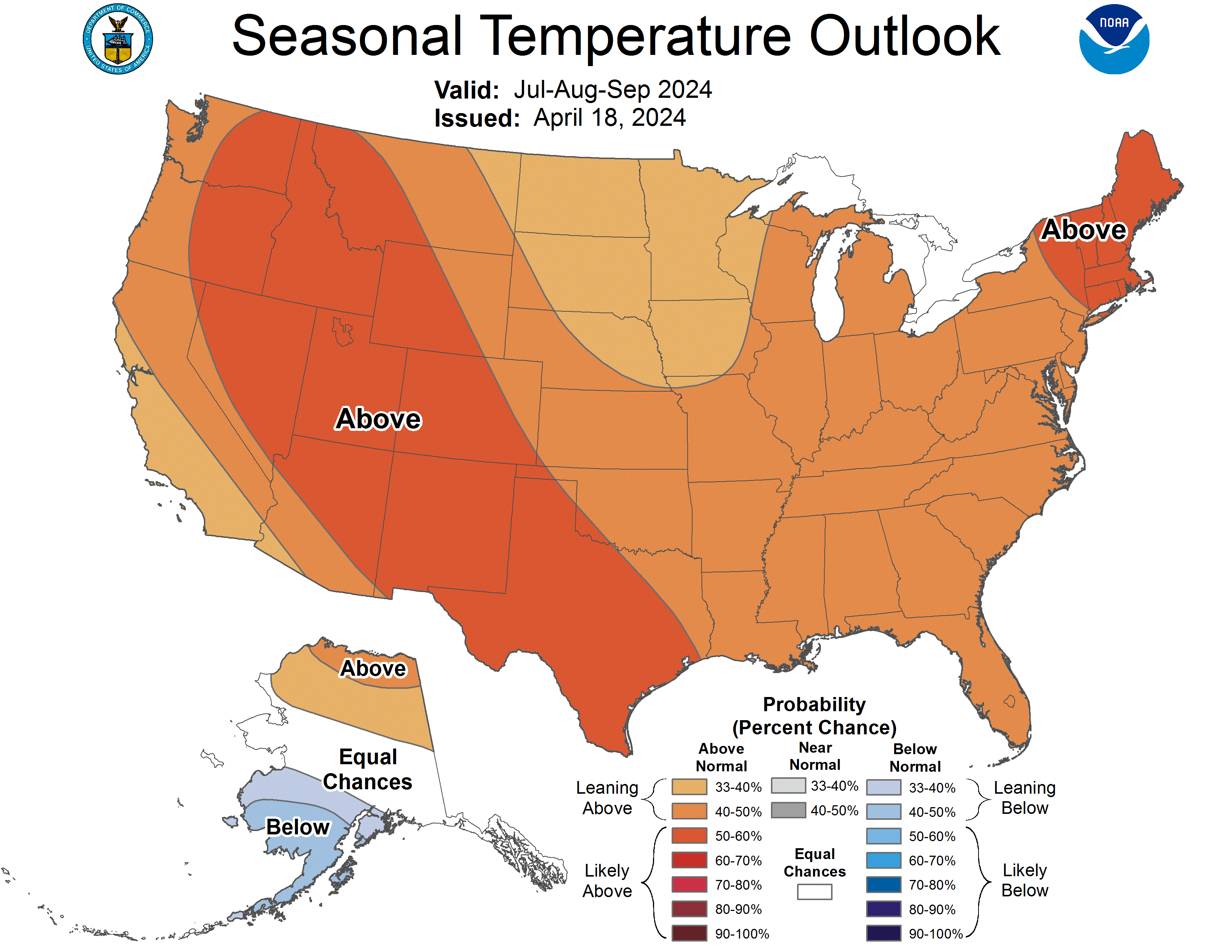
NOAA July – September temperature outlook

