About Jim Angel

Jim Angel is the state climatologist for Illinois and co-investigator on the U2U project.

El Nino and It’s Potential Impact on the Corn Belt

In early May 2015, the Climate Prediction Center reported that weak to moderate El Niño conditions were present in the Pacific Ocean basin, along the equator. Furthermore, there is a greater 90% chance it will continue through summer and a greater than 80% chance it will last through 2015.

Now that El Niño has arrived, it’s influence on the NWS climate outlooks released last Thursday is considerable. For June (first figure, top row), the Southern Plains are expected to have an increased chance of cooler-than-average temperatures. A large part of the US is expected to have an increased chance of wetter-than-average precipitation, including portions of the southern and western Corn Belt.

For the period June-August (first figure, second row), the increased chance for cooler-than-average conditions stretches northward and eastward and includes all of Kansas and Missouri, southern Nebraska and Iowa, and far western Illinois. Continue reading

2014 – Warmest Year on Record for World, 15th Coldest for Corn Belt

The year 2014 was considered the warmest year on record for the world, according to three different sources (Japan, NASA, and NOAA). Meanwhile, the Corn Belt experienced the 15th coldest year on record. How can that be?

First of all, here is how 2014 ranked state by state. Many of the Corn Belt states were much below normal, including the three “I” states – Iowa, Illinois, and Indiana as well as Missouri, Michigan, and Wisconsin. It was the 6th coldest year on record for Illinois and in the top 10% for the other states mentioned. The rest of the Corn Belt was below normal as well. Taken together, this was the 15th coldest year on record for the Corn Belt.

201401-201412

National Temperature rankings. NOAA National Climatic Data Center http://www.ncdc.noaa.gov/sotc/national/2014/13

Continue reading

NWS Outlook – Wet October for Northern Corn Belt

Much of the northern Corn Belt has an increased chance of above-average precipitation in October, according to the NWS Climate Prediction Center. This follows on the heels of above-average precipitation over the last 30 days across the Corn Belt.

In the map below, areas shaded in green have an increased chance of above-average precipitation in October and include the Dakotas, Minnesota, Wisconsin, Michigan, Iowa, northern Illinois, and northeast Missouri.

off14_prcp

Continue reading

NOAA Seasonal Outlooks – A Cool Finish To The Corn Crop?

On July 17, 2014, the NOAA Climate Prediction Center released their outlook for August and beyond.

Currently, we have significant heat through the High Plains and the Midwest. But it will be short-lived. The NWS forecast show cooler conditions returning soon to the region. The outlook for August (first map, click to enlarge) includes an increased chance of below-average temperatures across the upper Midwest, while the Southeast has as increased chance of above-average temperatures. Much of Illinois, Indiana, and Ohio have equal chances (EC) of above, below, and near-average temperature.

Much of the Corn Belt has equal chances (EC) of above, below, and near-average precipitation (second map) in August. In other words, there are no clear indications of an increased risk for too much or too little rain.

off14_tempoff14_prcp

Continue reading

NOAA Seasonal Outlook – Cooler in the Northern Corn Belt This Summer?

On June 19, the NOAA Climate Prediction Center released their latest monthly and seasonal outlook of temperature and precipitation for the US. One of the factors that will likely come into play this fall and winter is the developing El Niño event in the Pacific Ocean. Here is the breakdown of the outlooks. Unshaded areas show an equal chance of above, below, or near-average conditions and are labeled “EC”. Click on any map to enlarge.

JULY

There is an increased chance of cooler-than-average conditions in July for eastern Montana and Wyoming, northeast Colorado, western Nebraska, and nearly all of the Dakotas, Minnesota, and Wisconsin. The rest of the Corn Belt is in the “EC” category. At the same time, the Southeast has an increased chance of warmer-than-average conditions.

For precipitation, there is an increased chance of drier-than-average conditions in southern Missouri and Illinois. Meanwhile, there is an increased chance of wetter-than-average conditions in the Rockies and the western portions of the High Plains that could bring some relief to parts of drought-stricken Colorado, Nebraska, and Kansas.

off14_tempoff14_prcp

Continue reading

Waiting for Spring

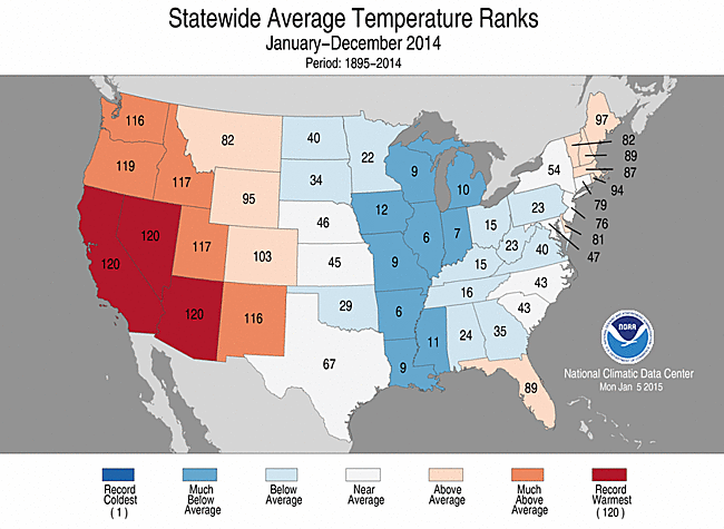
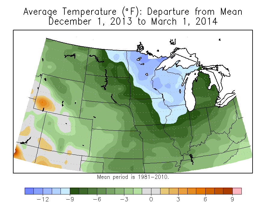
This winter has been significantly colder than average across the Corn Belt. The December-February temperatures were 9 to 12 degrees below average across Minnesota, Wisconsin, eastern Iowa, and northern Illinois. The rest of the Corn Belt was 6 to 9 degrees below average (map below). In addition, snowfall for the winter season was above average in the eastern two-thirds of the Corn Belt and near to slightly below average in the western third.

winter-temp-depart

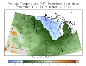
Temperature departures for the period December 1, 2013 to March 1, 2014 for the central US.  Click to enlarge.

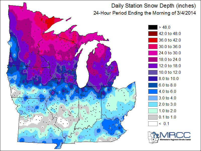
The results of this cold and snowy winter are that we have: 1) a significant snowpack in Minnesota, Wisconsin, Michigan, and in much of northern Iowa, Illinois, Indiana, and Ohio (see snow depth map below) and 2) frozen soils across much of the northern two-thirds of the Corn Belt.

DLY_SNDP_MAPS-0

Snow depth (inches) as reported on the morning of March 4, 2014.  Click to enlarge.

It will take some time for the snow to melt and the soils to warm up and dry out. The latest forecasts from the National Weather Service Climate Prediction Center indicate that colder than average conditions will prevail for at least the next two weeks. A slow melt is desirable at this point in order to reduce the risk of flooding on rivers and streams.

Soil moisture was in good shape going into winter in much of the eastern Corn Belt, but was below average in parts of the western Corn Belt. It remains to be seen how much of the snow melt will actually go towards recharging the soil moisture in those areas. It is likely that that the frozen soils will inhibit the recharge in many instances.

While there are concerns of a slow start to the growing season due to the cold weather, circumstances could change rapidly, as they often do in the Midwest. A few weeks of warm weather and sunshine in April could put us back on track.

Maps are courtesy of the Midwestern Regional Climate Center, Illinois State Water Survey and the University of Illinois.

Late Season Warmth and Dryness

Much of the Cornbelt experienced conditions warmer and drier than average in recent weeks. Temperatures for the first 25 days of September have been above average in the western two-thirds of the region with the departures becoming stronger moving from east to west. Meanwhile, much of Ohio and Indiana as well as parts of Illinois and Wisconsin have been close to average. After planting delays this spring and the cooler than average conditions that prevailed through mid-August, this late season warmth gave corn an opportunity to at least partially catch up in its development. In addition, it has served as an aid in drydown in those fields that have already reached maturity.

Based on the September 24, 2013, US Drought Monitor, the US Department of Agriculture estimates that 54 percent of the US corn production is in some stage of drought. At this late stage of the growing season, additional precipitation will have little impacts on yields. In fact, any significant precipitation at this point is more likely to be a hindrance as the harvest continues.

map-btd-2

corn-drought

Click to enlarge. Map courtesy of the US Department of Agriculture