
The late cold snap in December changed what could have been a rather historic situation, one where average December temperatures were actually warmer than November temperatures. Data is gradually coming in completing the data for the month of December. The much colder than average temperatures over the after Christmas have helped to bring down the December averages to close to, but generally slightly cooler than November overall.
To review what happened over the last two months, November started quite warm, but turned very cold in the middle of the month setting a large number of temperature records as sub-0 F temperatures showed up across parts of the Corn Belt mush earlier than usual. November ended at 6-10 F below average. The cold carried on into the first part of December when a sharp change occurred with very warm temperatures across the Corn Belt in December with most of the Upper Midwest 4-8 F above average. See attached images.
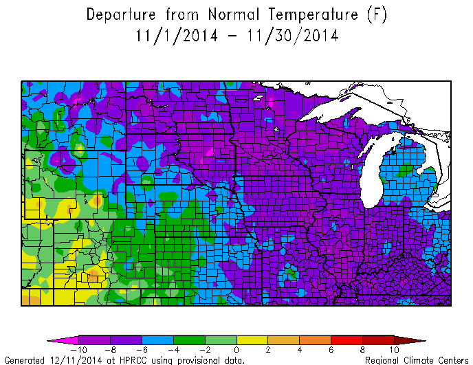
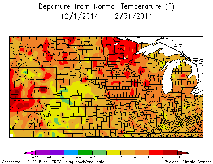
Final data are still being accumulated. Most of the stations around the Midwest and northern plains were within a couple degrees between the two months. The large majority of stations ended up slightly colder in December than November. But a few stations largely in northern areas ended up warmer in December than November.
How odd is this situation? First we have to look at climatology. There is a range of results across the Corn Belt comparing averages for the two months. But generally the average difference between November and December is 10-14 F. So that they are even close show the oddity of the event with November that cold and December that warm.
Has it ever happened? In some locations, no. But we can go back to a couple years and find a number of stations where it has happened, 1896 and 1959. Many stations have both of these with more showing the situation in 1959.
Enjoy the little bit of climatic history.

